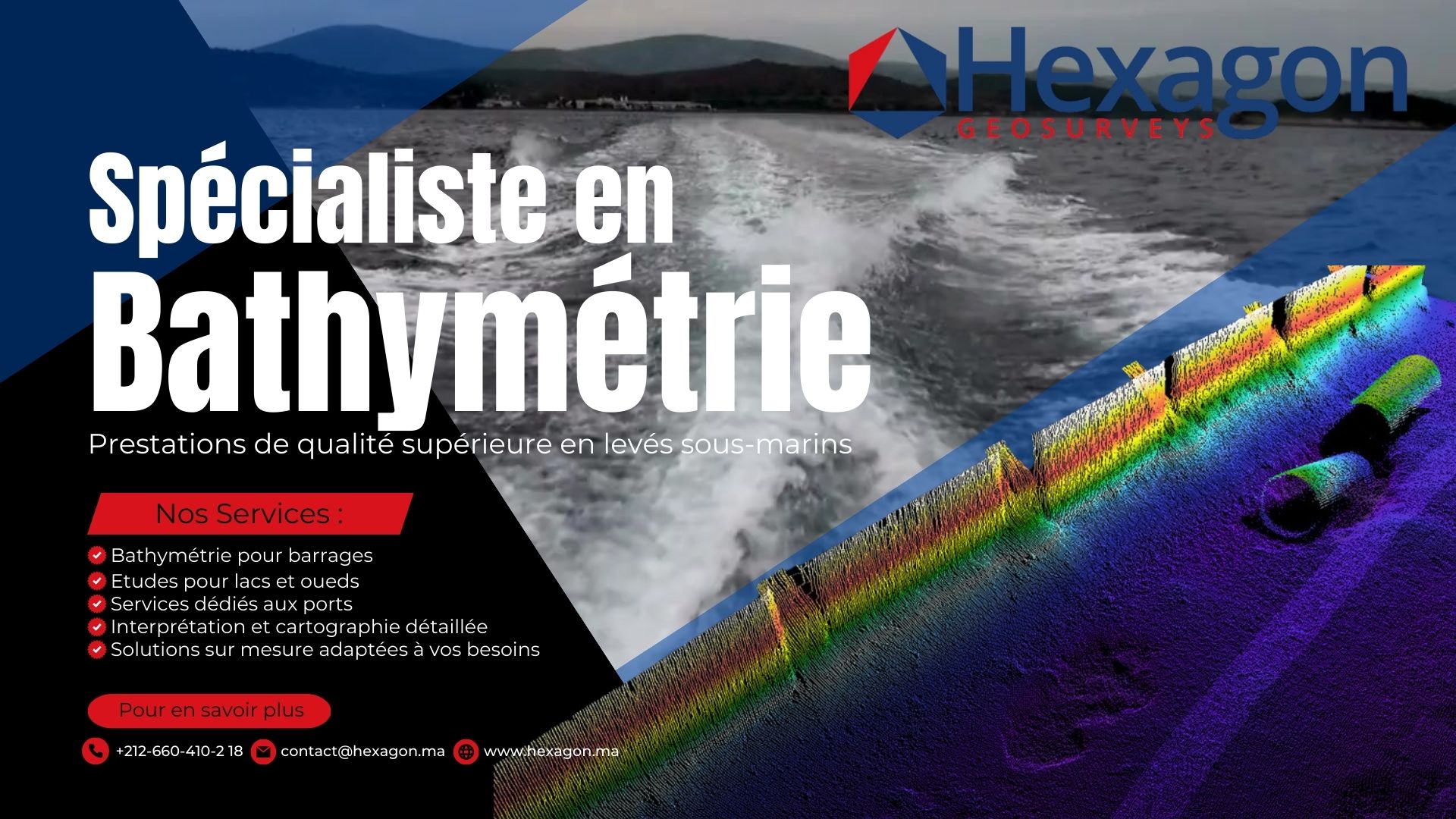
Bathymétrie. Ce terme, teinté de technicité et d’une importance incommensurable, évoque une quête constante de connaissance et de compréhension de nos milieux aquatiques. Au cœur du Maroc, un pays où les ressources en eau sont inextricablement liées à la vie quotidienne et à l’économie, la bathymétrie s’avère être un outil indispensable.
Dans ce contexte, comment les professionnels peuvent-ils identifier un prestataire de services bathymétriques qui non seulement répond à leurs besoins mais transcende également leurs attentes ? Quels sont les critères essentiels à considérer, et pourquoi une précision bathymétrique irréprochable est-elle capitale, notamment pour les structures telles que les ports, les barrages, les oueds et les lacs ?
Dans cet article, nous nous immergerons dans les aspects les plus techniques et cruciaux de la bathymétrie au Maroc, explorant en détail les 5 éléments clés à observer lors de la sélection d’un prestataire bathymétrique. Nous aborderons également l’importance du dragage et de l’inspection dans la gestion efficace de nos ressources en eau, et nous examinerons les livrables spécifiques que l’on devrait attendre de ces experts en bathymétrie.
Vous vous demandez peut-être quel rôle joue l’expérience et l’expertise dans ce processus ? Ou quels types de matériels devraient être utilisés pour assurer des résultats optimaux ? Restez avec nous, car cet article a été conçu pour répondre à ces interrogations et bien plus, offrant une perspective éclairée et approfondie sur le choix de prestataire bathymétrique au Maroc.
La bathymétrie : en quoi consiste-t-elle ?
Définition et processus
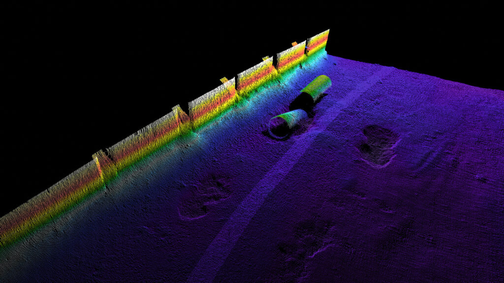
La bathymétrie, au carrefour de la science, de la technologie et de l’exploration, se définit comme l’étude et la mesure des profondeurs des océans, mers, lacs, rivières et autres étendues d’eau. Elle vise à produire une représentation topographique du fond marin ou fluvial, comparable à une carte de relief pour les régions terrestres. Pour ce faire, des instruments spécialisés comme les sondeurs sont employés pour capter des données précises sur la profondeur de l’eau en différents points. Ces informations sont ensuite traitées et interprétées pour donner naissance à des cartes bathymétriques détaillées.
Importance au Maroc
Le royaume du Maroc, avec ses vastes étendues côtières, ses lacs, ses oueds et ses barrages, place la bathymétrie au cœur de nombreuses préoccupations. Elle s’avère essentielle pour des domaines aussi variés que la navigation maritime, la planification hydrologique, ou encore les études environnementales. Les cartes issues de ces études sont par exemple des outils inestimables pour les navigateurs, offrant une vision claire des obstacles potentiels se cachant sous la surface aquatique.
Applications et enjeux
Outre les aspects liés à la navigation, la bathymétrie au Maroc trouve de nombreuses applications dans des secteurs tels que l’ingénierie et la construction. Une connaissance précise des fonds marins et fluviaux est indispensable pour des projets d’envergure, qu’il s’agisse de la mise en place de barrages, de la construction de ports ou d’autres infrastructures côtières. Avec les enjeux croissants liés aux changements climatiques et à la gestion des ressources en eau, disposer d’informations bathymétriques fiables permet d’anticiper et de répondre efficacement aux défis de demain.
L’importance de la bathymétrie dans les travaux de dragage et de l’inspection
Ports : Le dragage et l’inspection au service de la sécurité et de la navigabilité
Dans le contexte portuaire, les travaux de dragage sont indispensables pour maintenir les profondeurs nécessaires à une navigation sécurisée. En raison de l’accumulation naturelle des sédiments, les ports peuvent voir leur profondeur réduite, posant des risques pour la navigation, en particulier pour les grands navires. Avant toute intervention, un levé bathymétrique est réalisé pour évaluer les volumes de sédiments à extraire. Après le dragage, un nouveau levé assure que les objectifs de profondeur sont atteints. Parallèlement, les inspections régulières des infrastructures portuaires garantissent leur bon état et préviennent d’éventuels problèmes structurels.
Barrages : Dragage et inspections pour une gestion optimale
Les barrages, essentiels pour la rétention d’eau et la production d’électricité, sont aussi susceptibles à l’accumulation de sédiments. Cette accumulation peut compromettre leur capacité de stockage et, par conséquent, leur efficacité. Avant le dragage, un levé bathymétrique est effectué pour calculer la quantité de sédiments à retirer. Suite aux opérations, un levé post-dragage vérifie que la capacité de stockage est restaurée. Les inspections régulières des barrages, quant à elles, veillent à leur intégrité structurelle, garantissant ainsi une utilisation sûre et durable.
Oueds et lacs : Anticiper les risques et gérer efficacement les ressources
Les oueds et les lacs, cruciaux pour le cycle hydrologique, peuvent aussi être menacés par l’accumulation de sédiments, engendrant des risques d’inondation. Les travaux de dragage, précédés et suivis de levés bathymétriques, sont alors nécessaires pour garantir un écoulement régulier de l’eau. Ces levés permettent de planifier le dragage de manière précise et de s’assurer ensuite de son efficacité. Les inspections régulières des oueds et lacs contribuent également à une gestion proactive des ressources en eau, en surveillant la santé des écosystèmes aquatiques et en anticipant les besoins en matière de gestion de l’eau.
Sondeurs mono-faisceaux vs. sondeurs multifaisceaux : Comprendre leurs forces respectives
Les sondeurs mono-faisceaux et multifaisceaux jouent tous deux un rôle crucial en bathymétrie, bien qu’ils aient des caractéristiques et des avantages distincts.
Sondeurs mono-faisceaux : L’efficacité dans la simplicité
Les sondeurs mono-faisceaux émettent un seul faisceau sonore directement sous le navire pour mesurer la profondeur à un point précis.
-
Avantages:
-
Robustesse et fiabilité : Les sondeurs mono-faisceaux ont une conception moins complexe, ce qui les rend souvent plus robustes et fiables dans diverses conditions.
-
Idéal pour des mesures ponctuelles : Ils sont parfaits pour obtenir des mesures précises à des points spécifiques, ce qui est utile pour des études ciblées ou des vérifications ponctuelles.
-
Excellente performance en eaux profondes : Ces sondeurs excelles dans la mesure de profondeurs très importantes, souvent plus efficacement que les multifaisceaux.
-
Economiques : Leur simplicité se traduit souvent par un coût plus bas, les rendant accessibles pour de petits projets ou des budgets limités.
- Exemples d’utilisation : Ils sont souvent utilisés pour la surveillance de barrages, où des mesures régulières à des emplacements fixes sont nécessaires, ou pour des études géologiques ciblées où la profondeur de certaines structures précises doit être déterminée. Un autre exemple serait le suivi de la sédimentation dans des oueds ou des canaux spécifiques pour anticiper les besoins de dragage.
-
Robustesse et fiabilité : Les sondeurs mono-faisceaux ont une conception moins complexe, ce qui les rend souvent plus robustes et fiables dans diverses conditions.
Sondeurs multifaisceaux : La cartographie complète
Les sondeurs multifaisceaux, quant à eux, cartographient une zone plus large du fond marin grâce à l’émission de plusieurs faisceaux simultanément.
-
Avantages:
-
Cartographie détaillée : Ces sondeurs offrent une image complète et détaillée du fond marin, rendant visibles les structures et caractéristiques fines.
-
Rapidité : La capacité à cartographier de larges bandes du fond marin en une seule passe permet de gagner du temps lors de l’étude de vastes zones.
- Données supplémentaires : Ils peuvent offrir des informations sur la dureté, la texture et d’autres caractéristiques du fond.
-
Cartographie détaillée : Ces sondeurs offrent une image complète et détaillée du fond marin, rendant visibles les structures et caractéristiques fines.
Tout en reconnaissant les puissantes capacités des sondeurs multifaisceaux, il est essentiel de ne pas sous-estimer la valeur des sondeurs mono-faisceaux. Ces derniers, grâce à leur simplicité, leur fiabilité et leur précision à des points ciblés, continuent d’être un outil inestimable dans de nombreux projets de bathymétrie.
La qualité des livrables d’un prestataire bathymétrique
La qualité des levés bathymétriques est cruciale pour assurer la sécurité et l’efficacité des opérations maritimes. Pour garantir la fiabilité des données, il est essentiel de mettre en place un processus d’assurance de la qualité des livrables. Voici comment vous, en tant que maître d’ouvrage, pouvez vous assurer de la qualité des livrables fournis par le prestataire :
Dossier technique du levé bathymétrique
Ce dossier doit comprendre un rapport technique détaillé, des fiches spécifiques, des procès-verbaux (PVs) d’exécution, un rapport de calibrage du matériel, et des résultats du traitement des données brutes. Les plans bathymétriques 2D et 3D, ainsi que les plans des profils, remblais, et déblais, doivent être clairs, nets, et lisibles.
Signature et Authentification
Tous les documents doivent être signés et cachetés, soit physiquement soit numériquement, par un ingénieur géomètre topographe inscrit à l’ONIGT. Cette étape garantit que les livrables ont été supervisés et validés par un professionnel qualifié.
Support informatique et Données Numériques
Le prestataire doit vous fournir un support informatique contenant les données numériques éditées. Il est essentiel que ces données soient complètes, correctes, et présentées sous des formats exploitables. L’utilisation de standards et formats universellement reconnus (comme DWG, PDF, SHP, etc.) facilite l’interopérabilité et l’utilisation ultérieure des données.
Révision et Validation
Une fois les livrables reçus, vous devez procéder à une revue minutieuse. Cela comprend l’examen des données, la vérification des calibrations, l’analyse des rapports techniques, et la conformité des plans avec les normes établies. Si vous éprouvez des difficultés à comprendre ou à valider les livrables, nous pouvons intervenir en tant que partie tierce pour vous assister dans la validation des résultats.
Feedback et Corrections
En cas d’observations ou de remarques, vous devez informer le prestataire pour effectuer les corrections nécessaires. Le processus d’examen, de feedback, et de révision garantit que les livrables finaux sont d’une qualité optimale.
En mettant en œuvre ces étapes, vous pouvez assurer la qualité, la fiabilité, et l’exactitude des livrables bathymétriques, garantissant ainsi la sécurité et l’efficacité des opérations en mer.
L’importance cruciale d’une expérience locale au Maroc
Dans le domaine de la bathymétrie, l’expérience est plus qu’un simple indicateur de compétence ; elle est un gage de fiabilité, de connaissance approfondie des défis du métier et de la capacité à naviguer dans un environnement complexe et en constante évolution. Voici pourquoi l’expérience est particulièrement importante dans ce secteur :
Adaptation au climat local
-
Conditions variables : Les conditions météorologiques et océanographiques au Maroc, comme dans de nombreux autres pays, peuvent varier considérablement et influencer la qualité des données bathymétriques collectées. Seul un prestataire ayant une expérience locale significative peut anticiper et s’adapter à ces variations pour garantir la précision des mesures.
- Expérience terrain : Une connaissance intime des eaux locales, qu’il s’agisse de la côte atlantique, de la Méditerranée ou des lacs intérieurs, est essentielle pour anticiper les défis spécifiques à chaque région.
Compréhension de la réglementation
-
Complexité administrative : Le Maroc, comme beaucoup d’autres pays, possède une réglementation détaillée concernant la bathymétrie. Un prestataire expérimenté sera déjà familiarisé avec cette réglementation et pourra s’assurer que toutes les mesures sont conformes aux normes locales.
- Liaison avec les autorités : Une expérience prolongée dans le secteur permet également de construire des relations solides avec les autorités locales, facilitant ainsi les autorisations nécessaires et la validation des données
Engagement envers les normes HSE (Hygiène, Sécurité, Environnement)
-
Risques spécifiques : Les opérations bathymétriques comportent de nombreux risques, qu’il s’agisse de la manipulation d’équipements lourds, de la navigation en mer ou des défis environnementaux. Un prestataire ayant une longue expérience aura développé des protocoles stricts pour minimiser ces risques.
-
Formation continue : Une entreprise expérimentée s’assure que son personnel est régulièrement formé aux dernières normes HSE, garantissant ainsi la sécurité de ses équipes, la protection de l’environnement et la satisfaction du client.
- Préparation aux imprévus : En cas de problème ou d’accident, un prestataire expérimenté aura les connaissances et les ressources nécessaires pour réagir rapidement et efficacement, minimisant ainsi les perturbations et les risques.
En conclusion, tandis que la technologie et les équipements jouent un rôle crucial en bathymétrie, c’est l’expérience du prestataire qui garantit que ces outils sont utilisés de manière optimale. En choisissant un partenaire ayant une solide expérience sur le marché marocain, vous vous assurez non seulement d’obtenir des données précises, mais aussi que le travail sera réalisé en toute sécurité, dans le respect de l’environnement et conformément à la réglementation locale.

Coût vs. Valeur en Bathymétrie au Maroc
Lors de la demande de devis
Avant de solliciter un devis pour des travaux bathymétriques, une articulation claire et précise de vos besoins est primordiale. En fournissant une description détaillée de vos attentes, vous aidez le prestataire à comprendre exactement ce que vous recherchez, évitant ainsi les surcoûts liés à des modifications ultérieures.
Il est tout aussi essentiel de spécifier les livrables que vous attendez et dans quel format. Si vous traitez avec des données sensibles, l’ajout d’une clause de confidentialité est recommandé pour garantir la sécurité et la confidentialité de ces informations.
La détermination des modalités de paiement, en termes de montants et de calendrier, est également un aspect à ne pas négliger lors de la demande de devis. Elle peut influencer le coût global du service. Une pratique judicieuse serait d’obtenir plusieurs devis pour avoir une meilleure idée du marché et prendre une décision éclairée.
À quoi faire attention lors de la réception des devis ?
Lors de la réception des devis pour des travaux bathymétriques, il est essentiel de prêter attention à la précision avec laquelle l’ensemble des prestations est détaillé. Il faut s’assurer que le devis couvre toutes les étapes de l’étude, les méthodes employées et les livrables attendus.
Une partie non négligeable de l’examen consiste à identifier les coûts potentiels qui ne sont pas explicitement mentionnés. Cela inclut les frais de déplacement, les coûts liés au matériel utilisé, ou d’autres charges qui pourraient s’ajouter. La nature du matériel, par exemple, le recours à des technologies mono-faisceau ou multifaisceau, peut avoir une incidence sur le coût total.
Pour garantir que les travaux répondent aux normes nationales, la vérification de la conformité du prestataire avec les réglementations, telles que son inscription à l’ONIGT, est cruciale.
Conclusion
La sélection d’un prestataire pour les travaux bathymétriques n’est pas une mince affaire. De la nécessité de l’expérience dans un environnement où le climat, la réglementation complexe, et les impératifs HSE jouent un rôle crucial, à l’importance de comprendre en détail les livrables et de pouvoir garantir leur qualité, chaque étape est essentielle pour assurer la réussite du projet.
De plus, au-delà de la simple question du coût, il est primordial de comprendre la valeur réelle de ce que vous payez. Se poser les bonnes questions lors de la réception des devis et spécifier précisément vos besoins dès le départ sont des démarches fondamentales pour éviter les mauvaises surprises et assurer que l’investissement soit rentable.
C’est dans ce contexte que Hexagon Geosurveys se positionne comme un partenaire de choix. Forts de notre expertise en topographie et bathymétrie, nous sommes en mesure de vous guider, de vous conseiller, et de vous offrir des solutions sur mesure pour vos projets. N’hésitez pas à nous contacter pour en savoir plus et bénéficier d’une collaboration fructueuse.
Si vous êtes captivé par les nuances et la profondeur de la bathymétrie, et si vous reconnaissez le besoin d’une expertise pointue pour vos projets, qu’ils soient côtiers, portuaires, ou d’infrastructures sous-marines, n’hésitez pas. Chez Hexagon Geosurveys, nous sommes à la pointe de la technologie et des méthodologies de ce secteur spécialisé. De la cartographie des fonds marins à l’analyse détaillée des structures sous-marines, nous sommes votre garantie pour des données précises et une intervention optimale.
[email protected]
Pour plonger dans une bathymétrie d’excellence, qui allie précision, rapidité et rentabilité, contactez-nous. Laissez-nous être votre boussole dans cette exploration fascinante du monde sous-marin.